-
 Officials with the Michigan Department of Natural Resources have stationed five pumps near the dam to try and divert water as more rain and melting snow are projected in the forecast.
 -
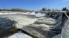 Water is now 18 inches from reaching the top, according to the Michigan State Police. If they reach 12 inches, the Michigan Department of Natural Resources says it will begin executing an emergency plan that will likely involved evacuations.
 -
 Nearly the entire Upper Peninsula is under an ice storm warning, with as much as half an inch of accumulation predicted in some areas, according to the National Weather Service.
 -
 The National Weather Service office in Gaylord told WCMU they don't expect the incoming system to be as severe as the ice storm and blizzard that struck the region a few weeks ago.
 -
 A key Doppler radar in Grand Rapids was down Monday afternoon as storms were expected overnight and severe weather chances increased Tuesday across parts of Michigan.
 -
 State and local officials across the Upper Peninsula are urging people to stay home and not travel unless necessary as a major winter storm continues to wreck havoc on the region, causing white-out conditions and heavy snow.
 -
 An ice storm warning expanded to 10 counties in northern Michigan. The Presque Isle County Sheriff's Office warned people to stay off roads.
 -
 The Mackinac Bridge Authority said they've closed the bridge as a precaution as the winter storm heading towards northern Michigan has created low visibility for motorists. It's unclear when it will reopen.
 -
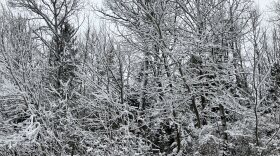 The National Weather Service says snow totals up to 4 feet are possible in some areas in the Upper Peninsula. Meanwhile, ice precipitation is possible for the northern Lower Peninsula.
 -
 The National Weather Service says residents that live north of Alpena into the Upper Peninsula will see heavy wet snow beginning Tuesday evening and in excess of six inches of snow.

© 2026 Central Michigan University
News, Culture and NPR for Central & Northern Michigan
Play Live Radio
Next Up:
0:00
0:00
Available On Air Stations


