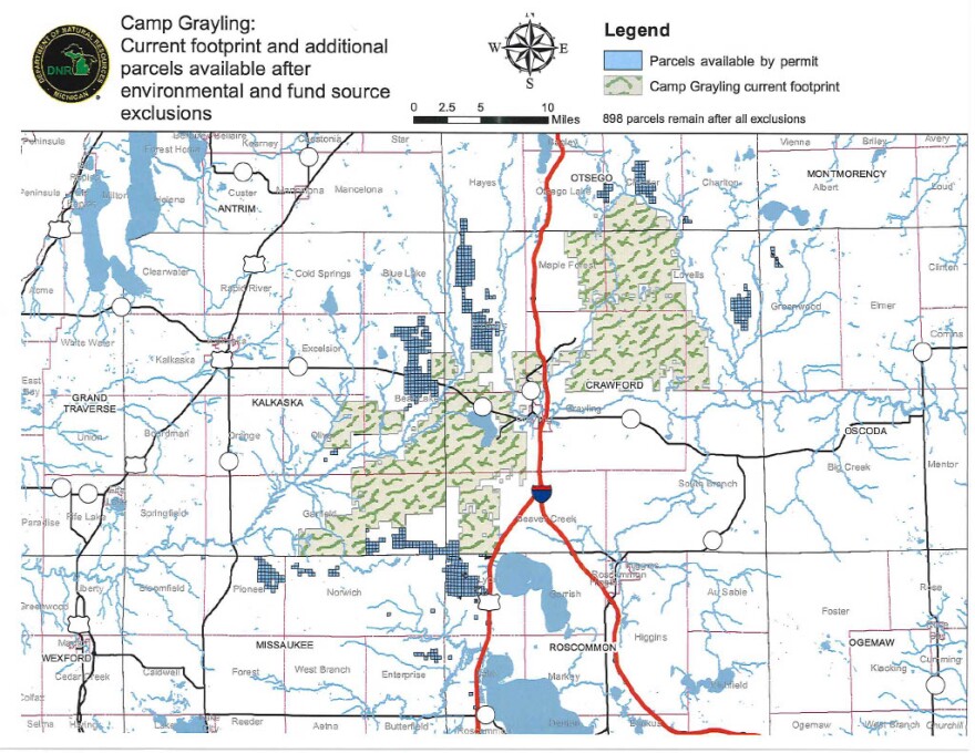
Maps are critical for military maneuvers, but now a map has become a sticking point on plans to potentially expand Camp Grayling.
In April, the state agreed to allow the National Guard to apply for permits on 52,000 acres of public land for “controlled trial[s] of cyber and electronic warfare technologies” and various other maneuver training that involve less than 500 National Guard members.
The acreage in the Memorandum of Understanding (MOU) between the Michigan Department of Natural Resources (DNR) and Michigan Department of Military and Veterans Affairs potentially raises the Camp Grayling footprint to 200,000 acres, extending into Crawford, Kalkaska, Roscommon, Missaukee and Otsego counties.
But local township and county officials near Camp Grayling say the map included with the DNR's MOU contract is no good.
The map shows several areas around Camp Grayling that are eligible for permitting, but it isn’t clear which specific parcels are included.

Documents obtained through the Freedom of Information Act reveal the state has yet to develop any shapefile map, or geographic information system file, that details specific parcels that would be used by the military after permitting is approved.
“I have been advised that the shape file will not be completed potentially until later this summer due to other work priorities,” said a DNR official in a response to a Freedom of Information request asking for a more detailed version of the map included in the MOU.
The DNR did not respond to WCMU’s request for comment on why it agreed to allow permit applications on public land without a map showing which specific parcels the permits would cover.
“We're anxious to fully understand this MOU, and all the ramifications of it and all the unanswered questions we have,” said Joe Hemming, president of Anglers of the Au Sable, a group dedicated to preserving land along the Au Sable River. “We're concerned about properly identifying the tax-reverted land.”
According to an email obtained by WCMU from Republican State Sen. Michelle Hoitenga, whose district includes Camp Grayling, the DNR hasn’t received any applications under the new MOU.
Sen. Hoitenga did not respond to multiple requests for comment.
Dozens of local townships and county commissioners in central and northern Michigan are in the middle of drafting new resolutions to oppose the MOU and any efforts to expand Camp Grayling.
More than 70 local governments passed resolutions opposing the National Guard’s 162,000-acre expansion that was denied in April.
Republican State Representative Ken Borton, whose district includes Camp Grayling, declined to comment on this story.
Editor's note: The Michigan Department of Natural Resources is a financial supporter of WCMU.


